


The Stone Men of Nine Standards Rigg
Mystery cairns on an ancient border...

Kirkby Stephen, Cumbria, England
Three years ago, on the last day of March, my friend and I set off to the lovely market town of Kirkby Stephen, Cumbria. Our destination was the mysterious cairns of Nine Standards Rigg.
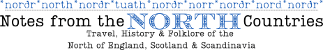
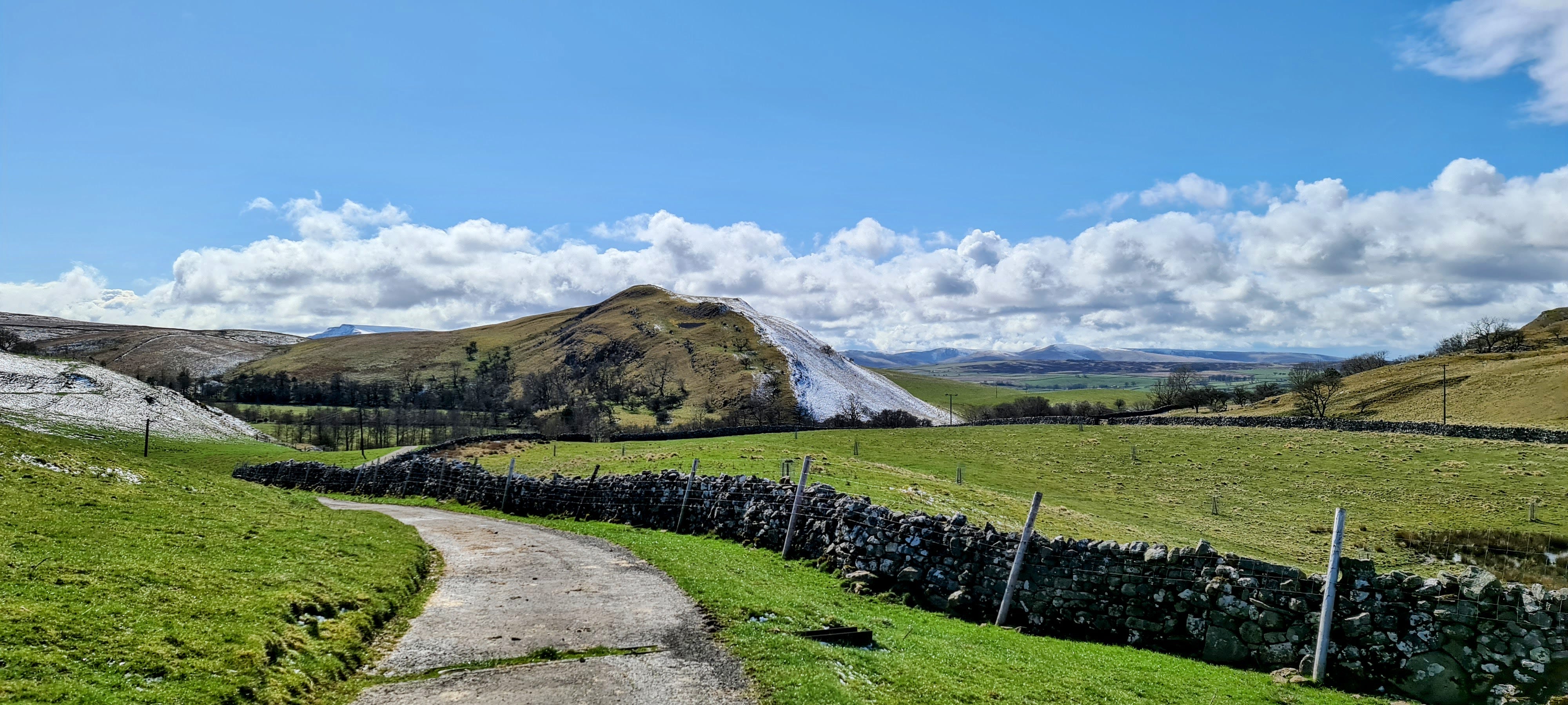
The weather forecast was supposed to be sunny, but cold. However, when I looked outside, there had been a dusting of snow. The route we took from Kirkby Stephen followed the quiet Hartley quarry road, which had been cleared so people could get to work, so the walking conditions were good.
The views on the way up were stunning. There was just enough snow to transform the landscape into a winter wonderland without making the walking conditions dangerous. We saw a couple of people walking their dogs on the quarry road, but after that, we saw no one else until we neared the summit of Nine Standards Rigg. I was surprised by this, as part of our route was on Alfred Wainwright’s Coast-to-Coast Walk.1
At a height of 692 metres (2,172 feet) and with a prominence of 157 metres (515 feet), Nine Standards Rigg is a mountain, a Hewitt, and a Marilyn.2 The Nine Standards lie a short distance from the summit, on the boundary between the ancient lands of Swaledale and Westmorland. This boundary also marks the watershed of the east and west Pennine Hills. The becks that run down the western side flow into the River Eden, which keeps moving westwards until it reaches the Solway Firth. Those on the eastern side trickle into the River Swale, which eventually meets the North Sea.

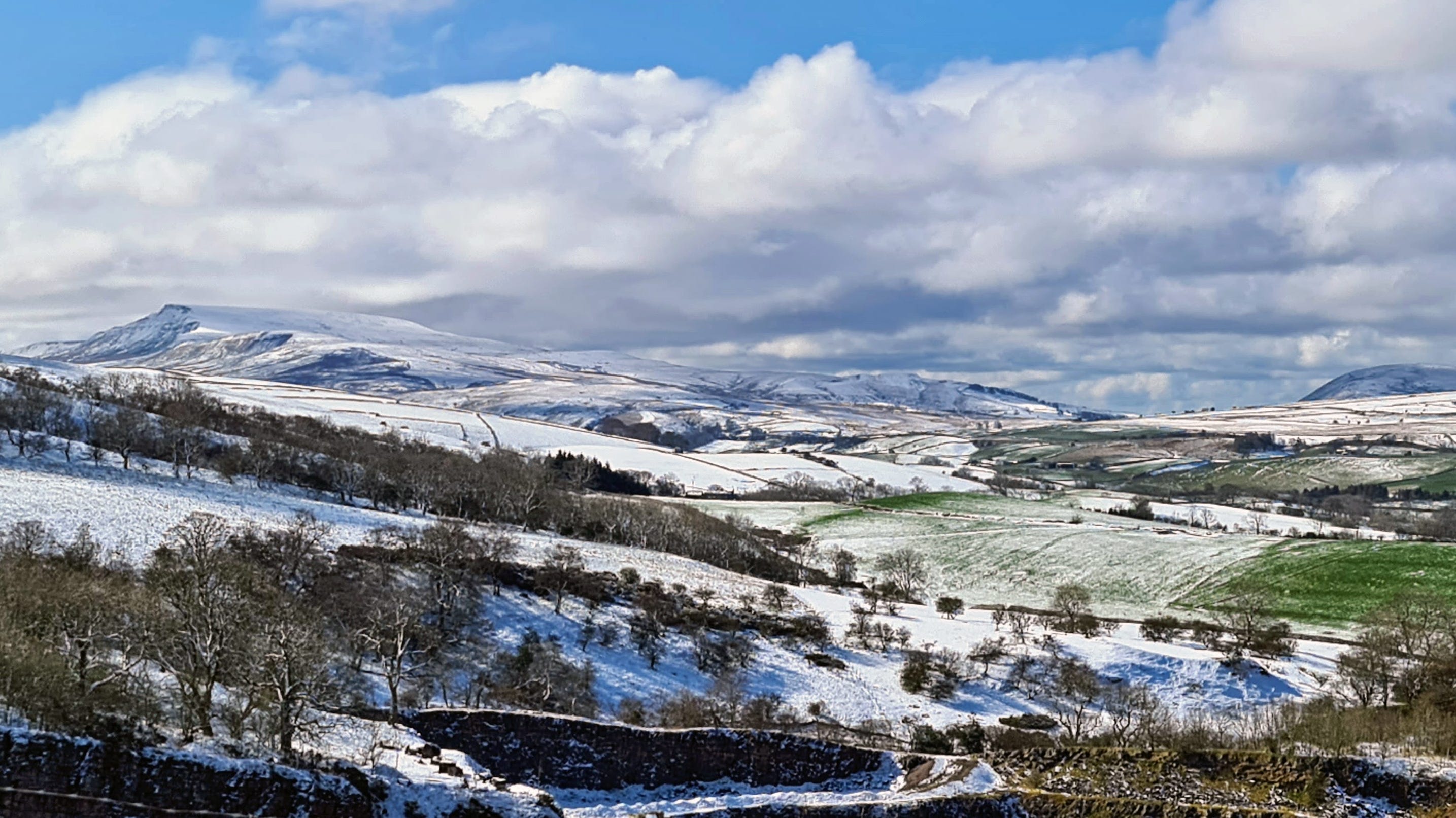
The Nine Standards
The cairns visible today have been rebuilt continually over the centuries. There is photographic and illustrative evidence from the last 100 years, showing that the number of cairns has varied over the years (from seven to twelve), as has their position. However, over this timeframe, the conical beehive shape of some of the cairns has remained. This is a similar shape to the monastic beehive cells found in Scotland, Wales, and Western Ireland. Today, the only visible evidence left of the original cairns is at the northern end of the Nine Standards, where you can see low, circular mounds on which the current cairns have been built—you can also identify at least one grassy, circular mound that is currently unoccupied.
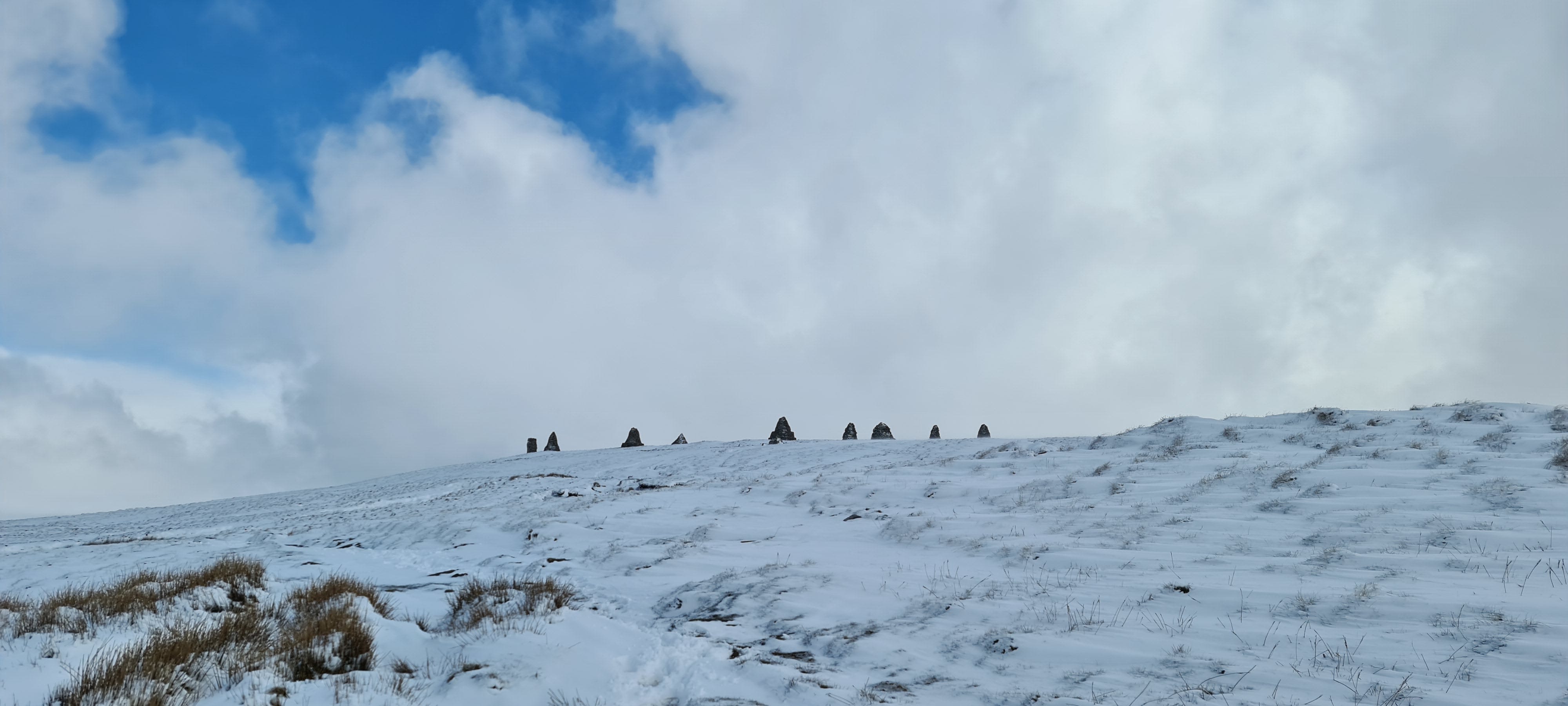
Each of the nine cairns differs in shape and size. The largest is the cone-shaped middle cairn. It is around 3.5 metres tall. They stand in an irregular line measuring 75 metres from end to end. It seems that the location of the Nine Standards was carefully chosen to maximise their visibility. They sit 400 metres away from the summit (and 12 metres lower); this location means they are far more visible from the valley below than they would have been if they had been constructed higher up on the actual summit.
Located in a very exposed position, the cairns are regularly battered by the elements. The wear and tear accumulated from howling winds, torrents of rain, snowstorms, and ice means they have needed rebuilding multiple times. The last time they were rebuilt was in 2005, so, at present, they are still in reasonably good shape.

Medievel,3 Viking, Roman?
The age and purpose of these mysterious cairns remain uncertain. The Nine Standards are on official maps dating back to 1770, and on a manorial map dating from 1738. However, they are not marked on (any known) maps before this date. Early maps generally used a large scale and were nowhere near as detailed as the mapping we are used to today. Therefore, just because the Nine Standards were not marked on these earlier maps certainly does not mean they did not exist.
Given that the cairns are built on the (disputed) ancient boundary line, it is probably not too surprising that the Nine Standards (or Nine Standers) are noted on many records referring to boundaries of parishes, townships, manors, and the like, the earliest of which dates from 1507. Records confirm that the boundary lines were established by the late 12th/early 13th century. These records imply that the Nine Standards (in some form or other) existed by the time the boundary line was first recorded (within a century or so of the Norman Conquest). However, unless new documents come to light, we will never be able to confirm this.

Some people have suggested that the Nine Standards may have been constructed by the Vikings or even the Romans. However, most of this is supposition. We do, however, know that much of the area was settled by people from Scandinavia in the 10th century. There are many Norse words in placenames in Cumbria and North Yorkshire, and many Viking artefacts have been found.4 I am interested in Nordic languages, so I was intrigued to read Stephen Walker’s theory5 that the name Nine Standards is derived from the Old Icelandic Niun Standa or Niun Stendr—Niun (nine), niunda (body of nine), standa/stendr (something standing or in a standing position). Similarly, we know that the Romans had a significant presence in the area, and there was a Roman fort called Verterae at Brough, less than eight miles away.
Memorial, Grave, Boundary Marker, or Stone Army?
As we don’t know how long these stone monoliths have been silently sitting on the fell6 top, it is currently impossible to ascertain who built them, or why they were built. Some have suggested they are simply boundary stones, which is probably the least exciting, but most plausible explanation. Another theory is that they were built as a memorial to the Legio IX Hispana of the Roman Army, which, in 118 AD, was seemingly decimated by the Picts, somewhere north of York. I think that this is unlikely tbh. Others have suggested that locals built the cairns to try and deter the marauding Scottish Army by making them believe there was an encampment of men on top of the fell. I don’t buy this hypothesis. I’ve seen the Nine Standards from many vantage points, near and far, and they look just like big stone cairns.
My favourite theory (although I admit that it is, in my opinion, somewhat fanciful) is that they were constructed to mark the grave of a Viking king with the fantastic name of Eirik Bloodaxe.7 Records show that Eirik—the last Viking King of Northumbria (and previously the King of Norway)—and the nobles he was with (allegedly five kings from the Hebrides and two earls from Orkney) were killed as they made their way through the Pennine Hills at Stainmore. The Kings' Sagas (Konungasögur) suggest that Eirik died in a bloody battle, now dubbed the Battle of Stainmore. However, contemporary historians suspect that Eirik had been exiled from York, and he and his group were ambushed and assassinated while they were heading for Scotland. Either way, it was long thought that Eirik was buried at Rey Cross; however, this site was excavated in 1990, when the dual-carriageway for the A66 was constructed, and no evidence of a burial was found. As the crow flies, the Nine Standards are just four miles away, and it has been suspected that it was Nine Standards Rigg where Eirik and the Scottish nobles met their demise and were buried.
Another option is that they were constructed purely for the sake of art; however, unless the site is thoroughly excavated, it is unlikely that we will ever discover their age or purpose. My feeling is that they are boundary stones.
A Walk in the Snow and the Sun
We were pleased to have the Nine Standards to ourselves. I can truly attest to their exposed position—it was bitterly cold and blowing a gale when we reached the cairns. I tried to eat my lunch without wearing gloves, but it was far too cold. We stopped for a while to admire the cairns and, when the clouds started to clear and the sun came out, the spectacular view. Whatever its history, it is a beautiful and very atmospheric place.
Thank you for reading. If you enjoyed this, please leave me a like and consider subscribing, sharing, or buying me a coffee.


The Coast to Coast Walk is a long-distance walk devised by Alfred Wainwright and published in his book A Coast to Coast Walk in 1973. From St Bees in Cumbria to Whitby in North Yorkshire, the walk passes through three National Parks (the Lake District, the Yorkshire Dales, and the North York Moors) and is just under 200 miles long.
In the UK, a hill has to be 2,000 feet or 609.6 metres high to be classed as a mountain. Hewitts are named after the initials of their definition—hills in England, Wales, and Ireland over two thousand feet (609.6 metres). They also require a minimum relative height of 98 feet (30 metres). Nuttalls are mountains in England and Wales that are over 2,000 feet (609.6 metres) and have a minimum relative height of 49 feet (15 metres).
I still don’t like spelling it this way!
The word Kirkby is likely derived from the Old Norse word kirkja, meaning church. Although this doesn't necessarily mean that there was a church building, it could mean that it was just a place of worship—the Vikings often worshipped their gods in natural places, like waterfalls, meadows, or even a large rock or boulder that had significance to them. St Stephen’s Church at Kirkby Stephen contains a Viking stone called the Loki Stone, which depicts the Norse God of Mischief and Deception.
You can learn more about Stephen Walker’s work on the history of the cairns at Friends of Nine Standards.
In Cumbria, the word fell describes a hill or mountain with steep slopes, rocky terrain, and a barren summit. Fell comes from the Old Norse word fjallr, meaning a large and flat mountain.
Eirik Bloodaxe (Eirik Haraldsson), was born in Norway in 885 AD. The son of the Norwegian king, Harald Fairhair, Eirik was King of Norway from 932 to 934, and King of Northumbria from 947 to 948, and again from 952 to 954. He was also occasionally known as Eirik Brother-Slayer, this is thought to be on account of him allegedly murdering his half-brothers in a power struggle concerning his rule over Norway. You can find out more about Eirik Bloodaxe on Wikipedia.
What a lovely post! Evocative of history, mystery and so many walks in the beautiful UK. Definitely adds the nine standers ( great exposition of the possible etymology btw) to my mental list of destinations. Thanks for this.